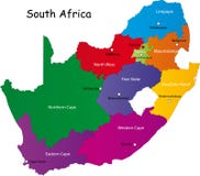
Illustration: South Africa Political Map
ID 103226214 © Peterhermesfurian | Megapixl.com
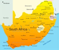
Political map of South Africa with the capitals Pretoria, Bloemfontein and Cape Town, with national borders, most important cities, rivers and lakes. Illustration with English labeling and scaling.
CATEGORIES
Sharing is not just caring, it's also about giving credit - add this image to your page and give credit to the talented photographer who captured it.:
KEYWORDS
africa atlantic atlas bloemfontein botswana cape cartography continent country durban elizabeth gaborone geography globe good hope illustration indian johannesburg kaapstadt kimberley kruger lesotho limpopo map maputo maseru mbabane mozambique namibia national ocean oranje park politically port pretoria south soweto state swaziland the town travels welkom windhoek world zimbabwe
More images on Dreamstime


Similar Images


More images by the same author


1 week free trial. Any size, for free
Renews at $25/month, cancel or upgrade at any time
Click here for your free trial!241,004,772 images | 1,215,002 contributors | 53,327,464 total users