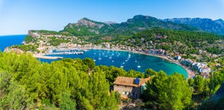
Stock Photo: Panoramic View On Quetzaltenango, Coming Down From The Cerro Quemado, Quetzaltenango, Altiplano, Guatemala
ID 100800917 © Letloose78 | Megapixl.com
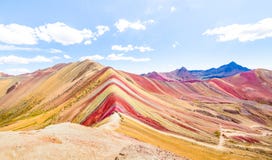
Quetzaltenango, also known by its Maya name, Xelajú or Xela is the second largest city of Guatemala. It is both the capital of Quetzaltenango Department and the municipal seat of Quetzaltenango municipality.nIt has an estimated population of 224,703. The population is about 61% indigenous or Amerindian, 34% Mestizo or ladino and 5% white Latin American. Quetzaltenango is located in a mountain valley at an elevation of 2,330 meters 7,640 feet above sea level at its lowest part. The Almolonga volcano, usually called `Cerro Quemado` Burned Mountain is an andesitic stratovolcano in the south-western department of Quetzaltenango in Guatemala. The volcano is located near the town of Almolonga, just south of Quetzaltenango, Guatemala`s second largest city.
CATEGORIES
EXCLUSIVE
Sharing is not just caring, it's also about giving credit - add this image to your page and give credit to the talented photographer who captured it.:
KEYWORDS
about above also altiplano american amerindian and around back both capital cerro city coming department down elevation estimated feet from guatemala has indigenous its known ladino largest latin level located lowest maya mestizo meters mountain mountains muela municipal municipalitynit name panoramic part population quemado quetzaltenango sea seat second summit valley view way white xela xelajaordm
More images on Dreamstime


Similar Images


More images by the same author


1 week free trial. Any size, for free
Renews at $25/month, cancel or upgrade at any time
Click here for your free trial!241,055,014 images | 1,215,075 contributors | 53,332,088 total users