Illustration: Europe Political Map And Surrounding Region
ID 50688708 © Peterhermesfurian | Megapixl.com
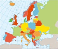
Europe Political Map and the surrounding region. Countries with national borders, big rivers and lakes. English scaling. Illustration.
CATEGORIES
Sharing is not just caring, it's also about giving credit - add this image to your page and give credit to the talented photographer who captured it.:
KEYWORDS
aegean arctic atlantic atlas austria balkan baltic belarus belgium black capital coastline continent country croatia czech denmark eurasia europe european finland france germany greece hungary ireland island italy kingdom map mediterranean netherlands norway ocean peninsula poland political republic sea spain sweden switzerland travel union united
More images on Dreamstime


Similar Images


More images by the same author


1 week free trial. Any size, for free
Renews at $25/month, cancel or upgrade at any time
Click here for your free trial!241,298,311 images | 1,215,535 contributors | 53,357,772 total users