Illustration: Central America Map - White Lands And Grey Water. High Detailed Political Map Central American And Caribbean Region With
ID 171026178 © Pytyczech | Megapixl.com
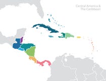
Central America map - white lands and grey water. High detailed political map Central American and Caribbean region with country, capital, ocean and sea names labeling.
CATEGORIES
Sharing is not just caring, it's also about giving credit - add this image to your page and give credit to the talented photographer who captured it.:
KEYWORDS
america american americas atlas border business capital caribbean cartography central city colorful continent countries country cuba dark design detail detailed education geographical geography green hue infographic information international isolated jamaica label labeled labeling map mexico name ocean oceans political sea shade state template travel vector water world
More images on Dreamstime


Similar Images


More images by the same author


1 week free trial. Any size, for free
Renews at $25/month, cancel or upgrade at any time
Click here for your free trial!241,004,772 images | 1,215,002 contributors | 53,327,801 total users