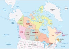
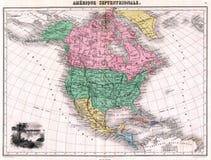
Canada Political Map with capital Ottawa, national borders, important cities, rivers and lakes. English labeling and scaling. Illustration.
CATEGORIES
Sharing is not just caring, it's also about giving credit - add this image to your page and give credit to the talented photographer who captured it.:
KEYWORDS
america americas arctic atlantic atlas bay calgary canada capital cartography charlottetown coastline country cruise destination erie fredericton geography greenland halifax hamilton hudson huron iceland illustration johns lake land london map michigan montreal newfoundland north ocean ontario ottawa political quebec saskatoon states superior toronto travel united vancouver windsor winnipeg yellowknife
More images on Dreamstime


Similar Images


More images by the same author


1 week free trial. Any size, for free
Renews at $25/month, cancel or upgrade at any time
Click here for your free trial!240,778,731 images | 1,214,395 contributors | 53,303,373 total users