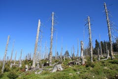
Illustration: Tracking Of Deforestation Through A Satellite Imagery
ID 273846244 © Horkins | Megapixl.com
Using satellite imagery to analyze forests and track deforestation helps us to monitor and combat the harmful effects of deforestation on our planet. Generative AI
CATEGORIES
Sharing is not just caring, it's also about giving credit - add this image to your page and give credit to the talented photographer who captured it.:
KEYWORDS
satellite imagery forests deforestation monitoring combat harmful effects planet environment technology forest loss conservation sustainability green earth climate change data analysis environmental protection remote sensing system global natural resources ecological biodiversity footprint degradation management land mapping crisis ecosystem vegetation services cover health restoration preservation development ecology science aerial gis
More images on Dreamstime


Similar Images


More images by the same author


1 week free trial. Any size, for free
Renews at $25/month, cancel or upgrade at any time
Click here for your free trial!243,240,529 images | 1,221,938 contributors | 53,541,407 total users