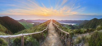
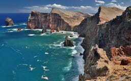
The easternmost tip of the island is a must for anyone wishing to explore the charms of Madeira's east coast. Ponta de São Lourenço offers a unique and imposing scenery with panoramic views over the north and south sides of the island. This volcanic peninsula is nine kilometres long. It is followed by Desembarcadouro Islet (Metade or Cevada Islet) and Farol Islet (Ponta de São Lourenço or Fora Islet). Due to its semi-arid climate and exposure to north winds, most of the vegetation in this area are creepers and there are no trees. Therefore, the landscape surrounding Ponta de São Lourenço and the rest of the island could hardly be in sharper contrast. This site is classified as a Partial Natural Reserve, given the relevance of its environmental heritage. Here you can find several rare plants and diverse fauna, including several protected sea birds, such as Cory's shearwater or Bulwer's petrel. With some luck, you may even spot sea lions. The best way to discover the natural and scenic richness of this peninsula is by walking the 6-kilometre round trip trail known as Vereda da Ponta de São Lourenço.
CATEGORIES
EXCLUSIVE
Your image is downloading.
Sharing is not just caring, it's also about giving credit - add this image to your page and give credit to the talented photographer who captured it.:
More images on Dreamstime


Similar Images


More images by the same author


Special Dreamstime offer
1 week free trial. Any size, for free
Renews at $25/month, cancel or upgrade at any time
Click here for your free trial!242,288,105 images | 1,219,093 contributors | 53,456,604 total users