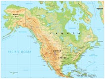
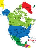
North America map showing countries, states, provinces, lat/long grid and oceans. Countries, states, provinces and oceans are labeled. Conic Projection.
CATEGORIES
EXCLUSIVE
Your image is downloading.
Sharing is not just caring, it's also about giving credit - add this image to your page and give credit to the talented photographer who captured it.:
More images on Dreamstime


Similar Images


Latest images


Special Dreamstime offer
1 week free trial. Any size, for free
Renews at $25/month, cancel or upgrade at any time
Click here for your free trial!240,482,477 images | 1,213,613 contributors | 53,271,568 total users