Illustration: New Zealand And Southern Polynesia, Political Map
ID 212702815 © Peterhermesfurian | Megapixl.com
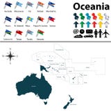
New Zealand and southern Polynesia, political map with capitals. Solomon Islands, Vanuatu, Fiji, Tonga, Samoa and New Caledonia. South Pacific Ocean islands. English labeling. Illustration. Vector.
CATEGORIES
Sharing is not just caring, it's also about giving credit - add this image to your page and give credit to the talented photographer who captured it.:
KEYWORDS
atlas basin caledonia capital cartography coral country fiji fire futuna geography girdle howe illustration island islands kermadec kiribati lord louisville map new niue norfolk north ocean pacific political polynesia ridge rim ring rise samoa sea solomon south tasman tokelau tonga trench tuvalu vanuatu vector wallis zealand
More images on Dreamstime


Similar Images


More images by the same author


1 week free trial. Any size, for free
Renews at $25/month, cancel or upgrade at any time
Click here for your free trial!242,282,142 images | 1,219,029 contributors | 53,456,412 total users