Illustration: Netherlands Antilles Political Map
ID 104144846 © Peterhermesfurian | Megapixl.com
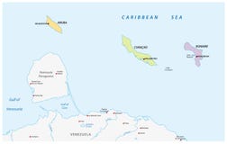
Netherlands Antilles Political Map. Aruba, Curacao, Bonaire, Sint Maarten, Saba and Sint Eustatius with capitals and important cities. English labeling and scaling. Illustration.
CATEGORIES
Sharing is not just caring, it's also about giving credit - add this image to your page and give credit to the talented photographer who captured it.:
KEYWORDS
abc abstract americas anguilla antilles aruba atlas bonaire capital caribbean cartography climate coastline cruise curacao destination dutch europe eustatius geography illustration island islands kralendijk leeward lesser maarten map martin michiel netherlands nicolaas nieuwpoort noord oranjestad philipsburg political saba saint sint soto sss travel tropical willemstad windward
More images on Dreamstime


Similar Images


More images by the same author


1 week free trial. Any size, for free
Renews at $25/month, cancel or upgrade at any time
Click here for your free trial!241,232,666 images | 1,215,421 contributors | 53,351,119 total users