Search results
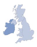
Illustration: Map Of United Kingdom Coloured With Union Jack Flag
ID 147884440 © Thiru123 | Megapixl.com
A high-resolution, political administrative boundary map of United Kingdom coloured with Union Jack flag. The map shows England, Ireland and Scotland on a white background. A transparent, isolated image is also available in PNG format.
CATEGORIES
EXCLUSIVE
Your image is downloading.
Sharing is not just caring, it's also about giving credit - add this image to your page and give credit to the talented photographer who captured it.:
More images on Dreamstime


Similar Images


Latest images


Special Dreamstime offer
1 week free trial. Any size, for free
Renews at $25/month, cancel or upgrade at any time
Click here for your free trial!241,304,644 images | 1,215,546 contributors | 53,358,455 total users