Search results
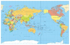
Illustration: Hi Detail Colored Vector Political World Map Illustration
ID 47901068 © Fourleaflover | Megapixl.com
High Detail Vector Political World Map illustration, cleverly organized with layers. With Country, Capitals, Main Cities, Seas and Lakes names all on different layers Original maps are from Cia ( for political borders and informations, NASA ( for geographical Features.
CATEGORIES
Your image is downloading.
Sharing is not just caring, it's also about giving credit - add this image to your page and give credit to the talented photographer who captured it.:
More images on Dreamstime


Similar Images


More images by the same author


Special Dreamstime offer
1 week free trial. Any size, for free
Renews at $25/month, cancel or upgrade at any time
Click here for your free trial!240,504,107 images | 1,213,707 contributors | 53,273,977 total users