Illustration: Greater Antilles Political Map
ID 90300313 © Peterhermesfurian | Megapixl.com
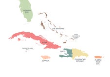
Greater Antilles political map. Caribbean islands. Cuba, Jamaica, Haiti, Dominican Republic, Puerto Rico, Cayman Islands, The Bahamas, Turks And Caicos Islands. Illustration. English labeling. Vector.
CATEGORIES
Sharing is not just caring, it's also about giving credit - add this image to your page and give credit to the talented photographer who captured it.:
KEYWORDS
americas andros antilles atlas bahamas caicos capital caribbean cartography cayman cockburn country cruise cuba destination domingo dominican english florida geography georgetown greater haiti havana illustration islands jamaica juan kingston labeling map nassau political port prince puerto republic rico san santo town travel turks vector
More images on Dreamstime


Similar Images


More images by the same author


1 week free trial. Any size, for free
Renews at $25/month, cancel or upgrade at any time
Click here for your free trial!240,611,183 images | 1,213,971 contributors | 53,286,083 total users