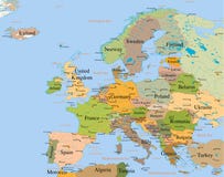
Illustration: Europe Subregions, Geoscheme For Statistical Purposes, Political Map
ID 249968398 © Peterhermesfurian | Megapixl.com
Europe subregions, political map. Geoscheme, that subdivides the European continent into Eastern, Northern, Southern, and Western Europe, for statistical purposes, and represented in different colors.
CATEGORIES
Sharing is not just caring, it's also about giving credit - add this image to your page and give credit to the talented photographer who captured it.:
KEYWORDS
atlantic atlas background baltic border boundary british cartography color colors continent country destination eastern europe european france geography geoscheme germany group groupings illustration infographic island isles italy land map mapping mediterranean nation northern overview political region russia scandinavia southern spain specific statistical statistics stats subdivision subregion travel vector western white
Similar Images


More images by the same author


1 week free trial. Any size, for free
Renews at $25/month, cancel or upgrade at any time
Click here for your free trial!243,797,982 images | 1,223,649 contributors | 53,594,895 total users