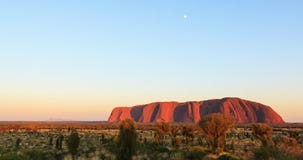
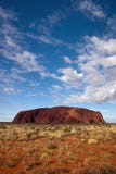
Uluru also known as Ayers Rock, is one of Australia's most recognisable icons. It is a large sandstone rock formation in the southern part of the Northern Territory, central Australia. It lies 335 km (208 mi) south west of the nearest large town, Alice Springs; 450 km (280 mi) by road. Kata Tjuta and Uluru are the two major features of the Uluru - Kata Tjuta National Park. Uluru is sacred to the Pitjantjatjara and Yankunytjatjara, the Aboriginal people of the area. It has many springs, waterholes, rock caves and ancient paintings. Uluru is listed as a World Heritage Site. Uluru is one of Australia's most recognisable natural icons. The world-renowned sandstone formation stands 348 m (1,142 ft) high (863 m/2,831 ft above sea level) with most of its bulk below the ground, and measures 9.4 km (5.8 mi) in circumference. Both Ayers rock and Kata Tjuta have great cultural significance for the Aṉangu Traditional landowners, who lead walking tours to inform visitors about the local flora and fauna, bush foods and the Aboriginal dreamtime stories of the area. Ayers rock is notable for appearing to change colour as the different light strikes it at different times of the day and year, with sunset a particularly remarkable sight when it briefly glows red. Although rainfall is uncommon in this semiarid area, during wet periods the rock acquires a silvery-grey colour, with streaks of black algae forming on the areas that serve as channels for water flow.
CATEGORIES
Sharing is not just caring, it's also about giving credit - add this image to your page and give credit to the talented photographer who captured it.:
KEYWORDS
aboriginal aborigine alice amazing ancient astonishing attractive australia ayers basalt beautiful boulders breathtaking cave caves dazzling distinctive docker dome domed dramatic dreamtime exceptional extravagant formation glowing gorgeous grand granite great group heads image impressive incredible indigenous kata legend magnificent national northern olgas paintings park people photo photograph photography pitjantjajara pretty remarkable river road rock sacred sandstone site snake springs striking stunning summit territory tjuta tourism tourist travel travelling tremendous uluru unique unusual vibrant vivid wall wanambi waterholes
More images on Dreamstime


Similar Images


More images by the same author


![Queen Hatshepsut Mortuary Temple [Ad Deyr al Bahri, Egypt, Arab States, Africa]](https://thumbs.dreamstime.com/t/queen-hatshepsut-mortuary-temple-ad-deyr-al-bahri-egypt-arab-states-africa-situated-beneath-cliffs-deir-el-bahari-31315639.jpg)
![Felucca in Front of Aswan Dam [Aswan, Egypt, Arab States, Africa].](https://thumbs.dreamstime.com/t/felucca-front-aswan-dam-aswan-egypt-arab-states-africa-traditional-wooden-sailing-boat-used-protected-waters-red-31315662.jpg)


![Abu Simbel Greater (Great) Temple - Statues of King Ramesses II (2nd) [Near Lake Nasser, Egypt, Arab States, Africa]](https://thumbs.dreamstime.com/t/abu-simbel-greater-great-temple-statues-king-ramesses-ii-nd-near-lake-nasser-egypt-arab-states-africa-archaeological-site-31315489.jpg)


1 week free trial. Any size, for free
Renews at $25/month, cancel or upgrade at any time
Click here for your free trial!239,794,899 images | 1,211,405 contributors | 53,196,251 total users