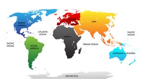
Illustration: Six Continents World, Political Map
ID 118825283 © Peterhermesfurian | Megapixl.com
Six continents world, political map. America, Africa, Antarctica, Asia, Australia and Europe, with shorelines and borders. Robinson projection. English labeling. Isolated on white background. Vector.
CATEGORIES
Sharing is not just caring, it's also about giving credit - add this image to your page and give credit to the talented photographer who captured it.:
KEYWORDS
africa america antarctica area asia atlas australia background border cartography chart coastline colors continent continents earth english europe geography global globe illustration island isolated labeling landmass map national ocean oceania political projection regions robinson sea shoreline silhouette six surface vector white world
More images on Dreamstime


Similar Images


More images by the same author


1 week free trial. Any size, for free
Renews at $25/month, cancel or upgrade at any time
Click here for your free trial!240,226,205 images | 1,212,889 contributors | 53,244,411 total users