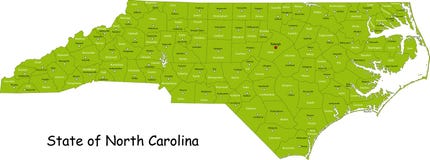
Colorful illustrated design of the map of North Carolina (USA), including counties and county seats. Isolated against a white background.
CATEGORIES
EXCLUSIVE
Your image is downloading.
Sharing is not just caring, it's also about giving credit - add this image to your page and give credit to the talented photographer who captured it.:
More images on Dreamstime


Similar Images


More images by the same author


Special Dreamstime offer
1 week free trial. Any size, for free
Renews at $25/month, cancel or upgrade at any time
Click here for your free trial!240,269,969 images | 1,212,969 contributors | 53,250,138 total users