Illustration: New York State Nys, Political Map
ID 177035538 © Peterhermesfurian | Megapixl.com
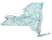
New York State NYS, political map, with capital Albany, borders, important cities, rivers and lakes. State in the Northeastern United States of America. English labeling. Illustration. Vector.
CATEGORIES
Sharing is not just caring, it's also about giving credit - add this image to your page and give credit to the talented photographer who captured it.:
KEYWORDS
albany america atlas border buffalo canada capital cartography champlain city connecticut country english erie falls finger geography hudson illustration island lake lakes long map mapping new niagara nys ontario placid political river rochester state states syracuse toronto united usa utica vector vermont york
More images on Dreamstime


Similar Images


More images by the same author


1 week free trial. Any size, for free
Renews at $25/month, cancel or upgrade at any time
Click here for your free trial!239,946,894 images | 1,211,857 contributors | 53,213,172 total users