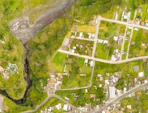
Stock Photo: High Resolution Orthorectified, Orthorectification Aerial Map Used For Photogrammetry
ID 114324507 © Ammit | Megapixl.com
High Resolution Orthorectified, Orthorectification Aerial Map Used For Photogrammetry Panecillo Hill In Quito Ecuador
CATEGORIES
Sharing is not just caring, it's also about giving credit - add this image to your page and give credit to the talented photographer who captured it.:
KEYWORDS
aerial america area construction development digital distance drone ecuador elevation engineer engineering flying geodesy georeferenced geospatial gis ground gsd hill industry inspection investigation land large map mapping model modern mosaic multirotor nadir orthorectification orthorectified panecillo photogrammetry populated professional quito site south space supervising survey surveying surveyor technology terrain tool top uas uav urban
More images on Dreamstime


Similar Images


More images by the same author


1 week free trial. Any size, for free
Renews at $25/month, cancel or upgrade at any time
Click here for your free trial!240,375,922 images | 1,213,241 contributors | 53,260,691 total users