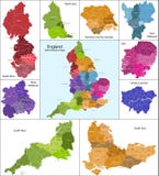
Illustration: England Map With Administrative Divisions.
ID 124878454 © Molokowall | Megapixl.com
Stylized vector England map showing big cities, capital London, administrative divisions and country borders
CATEGORIES
Sharing is not just caring, it's also about giving credit - add this image to your page and give credit to the talented photographer who captured it.:
KEYWORDS
atlas background border cartography circle city continent contour country district education england geographic geography grey ground identity infographic information isolated land location london map mapping nation national orange outline political politics region state subdivision symbol territory topography town travel vector white world
More images on Dreamstime


Similar Images


More images by the same author


1 week free trial. Any size, for free
Renews at $25/month, cancel or upgrade at any time
Click here for your free trial!240,398,304 images | 1,213,416 contributors | 53,262,901 total users